Friday
With nothing to hold us near Granada or Parque Nacional Volcán Masaya, we decided to do some stocking up and head to Isla de Ometepe, the next place on our list. Isla de Ometepe is the largest volcano island in a freshwater lake. Its name means island of two mountains, which are volcanoes. Volcán Concepción is the taller, active volcano, while Volcán Maderas is dormant and covered in a cloud forest.
To get to this island, you must take a nearly-2-hour ferry ride. We arrived with enough time to catch the Milton Arcia at 2:30pm. It wasn’t very clear where you purchased tickets and such, but once we got directed to the right location, it wasn’t too bad. We paid C$480 for the van’s fare and C$140 for the both of us, making the total about $24.80. But then we had to pay “taxes” for the tickets separately when we entered the ferry terminal area. The totals were about another C$100, all in all not too bad. Taxes and tickets were less than US$30.
We managed to get Chuck safely onto the ferry. The hardest part being getting him into the exact spot the operators wanted, which was mostly just almost scrapping the van’s side against the wall, but we finally made them happy. After we thought we were done, we went and sat down. However, shortly, an attendant came and told us that we needed to move again. When we got back on the vehicle deck, another guy who had been told the same thing said that the head honcho said that we didn’t need to move, that the guys were mistaken. So we went back inside. Apparently not the most organized crew in the world, but they got the other vehicles settled and we were off.

 Note, there is barely enough clearance for me to squeeze between those vehicles. Jonathan actually had to get in and out of the van via the back hatch.
 On the way, we talked with a nice lady who owned a bed and breakfast (currently closed for vacation) on the island. As we talked, we learned about the nice places on the island, where she had traveled, and Nicaraguan life in general. Apparently they had in just recent years initiated taxes on the island. The locals were outraged. It was funny to hear that the locals thought it was ridiculous that they had to pay for the road that was being constructed in front of their place. Previously, grants or donations or loans from other countries like Japan paid for such upgrades. The lady, an American expat, had to explain to her friends that that was how the rest of the world works. During the ride, a storm came up suddenly and started the drenching everything in sight. The ferry’s front door had a window missing, so we were getting sprayed a bit, despite everything being closed up. It passed quickly though.
When we arrived on the island, we simply drove off the ferry and started following the GPS. When we turned left instead of the right that I was expecting, I was immediately concerned that the GPS would be taking us the slower, bumpier route. So I was pleasantly surprised to find the paved road continued outside of town (our map showed differently). That pleasantness didn’t last long, though. Within a mile, the pavement ended and we were on the bumpy road that I had been expecting. Jonathan hadn’t read the same things I had, so he thought that road might get better. I had read that roads on the eastern half of the island were exactly this and we were proceeding directly along the eastern half of the island. Jonathan thought it might change at the split in the road. When it only got worse, we decided to turn around and take the slightly-lengthier-but-less-bumpy-and-probably-quicker route along the western half of the island. We basked in the smooth ride on the pavement.
The island was interesting to drive. The locals’ attitude to the road and the cars reminded me of my hometown’s attitude. They simply walked down the middle of the road and expected the car to yield to them. This was especially bad at 3pm when we got off the ferry because school had just gotten out and the kids were walking home. Another interesting part was the airstrip. It was perpendicular to the road and went right through the road. Literally. There wasn’t a bridge or underpass or anything. They just put up fences around the air strip with gates where the road intersected it. These were left open most of the time, and then there were orange cones along the airstrip where the road was so that they knew they couldn’t have anyone land or take off.
As we got to the isthmus connecting the two mountains and turned onto the east side, I was again expecting the road the turn into unpaved bumpiness as every mile passed by. But I guess a lot has changed in last year and the road has been paved from Moyagalpa to Altagracia (along the western side) to Balgue. So we were pleasantly surprised to find all of our path completely paved except from the turn off the main road to Finca Magdalena. The less-than-one-mile road to Finca Magdalena was more of what we had been expecting for the entire eastern side—slow and bumpy, but we made it safely.
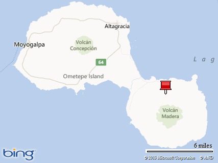
Finca Magdalena is at the red pushpin. Balgue is just north of that. You can see how it doesn’t look like it will be a good road to there.
By this time it was about 4 or 5 pm. We got situated, made some dinner and then I required a movie. My finger was throbbing and I was tired. When I hurt, I like stories—whether it is in a book or movie, but movies are easier. So we pulled out the bed and pulled up House, M.D., Season 3. We have been watching it since we left Tulsa, so we watched another two episodes before falling asleep.
No comments:
Post a Comment